Its been a stormy weekend here in Chicago. Repeated rounds of extremely heavy rain and vivid lightning have bombarded the area since Thursday night. I never managed to get any lightning shots as it seems like the bulk of the lightning activity managed to evade my house with the exception of those random 2 or 3 strikes that are really close during a 3hr long storm barrage.
The bigger story has been the flooding though, in fact Chicago just recorded its wettest day ever with O'hare Airport picking up 6.91" of rain on Saturday, which outsed the previous record of 6.64 in September of 2008 when the boring, thunderless remnants of a hurricane dumped on us for a couple days.
Here is a local news story about the event [probably time sensitive so I dont know how long the link will be valid: http://www.wgntv.com/wgntv-overnight-storm-july23,0,6626062.story
While the rain at O'hare was incredible, we got about 4" less here at Midway, which just goes to show how much it can vary during these events. A tidbit of irony is that exactly one year ago on the very same date, the Midway area was hit with 7" of rain in one day and the massive flooding was affecting my neighborhood. I have a write up on that event on my site which can be seen here: http://www.chicagoillinoisstormchaser.com/072310-chicago-severe-weather.php
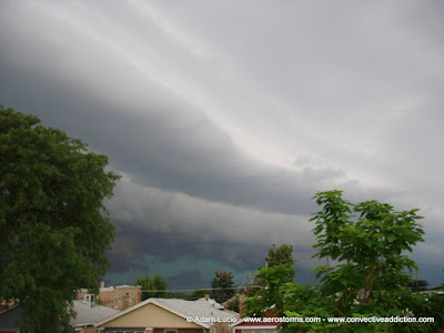
The photogenic prize for the weekend was a wicked shelf cloud that passed over early Friday morning, you dont often see structure and colors like this around here, so it was a real treat, but hard to capture in full due to the buildings and neighborhood trees. More can be seen on my homepage.
Since I have a weird date obsession with storms, it appears I will have to look forward to July 23rd 2012! Though usually once I notice a coincidence in the dates in which my area gets hit with storms is when the pattern ends. Today should be the last day of storms here, and normal people will finally get some weather they enjoy, while I look forward to a similar pattern rebuilding around Wednesday and potentially lasting 3 or 4 days. I love summer ring of fire patterns.


No comments:
Post a Comment